The Ewing Trail begins at Thomas Walker Civic Park. You can discern from the bundling, that the day was quite chilly.
Given the large cliffs above, it is actually quite surprising that there are not more boulders downslope. However, the one large one had a very curious pattern and color on one flank. It has a significant iron deposit.
We ran into a snowline from the night before. Evidence in the valley suggested that it had rained most of the night and only early had it snow a bit. Here, though light, it seems to have been all snow.
Walking up the mountain caused very little trouble staying warm, but on the ridgeline, evidenced by snow stuck to the NW side of branches, the wind along with the lack of slope to walk made for difficulty staying warm.
White Rocks shone in the sun for just moments, and I caught the tail end of the shine.
The trail switch backed up the ridge for reasons of erosion but also in order to snake between the cliffs.
Bro and Sis stand in the breach for a picture, too.
Not being one to be left out, so did I.
The pitting in the rock, algae and moss, and ice cycles produced an eerie face.
I would guess that the cliffs are 150' tall at this point. Later, on the drive home, I noticed that the cliff runs unbroken for at least two miles to the NE. The ridge and valley system of SW Virginia and E Tennessee lay before us. The breeze abated and the sun peeked out of the broken overcast intermittently to allow a respite, contemplative views, and needed snack.
The next four photos are my "panoramic view" from NE around to the E to the SW. The sandstone caprock was curiously pitted and gapped by more erosion ready rock. Where is the talus and boulder field. Was it predominantly limestone that dissolved?
I think that the hint of virga under the clouds is snow, showers of which we experienced intermittently throughout the hike.
There was no doubt about which way the snow came from.
Later in the trip the brother/sister combo bushwhacked a short distance off trail to the top of yon knob to make contact with seven radio operators, establishing a "Peak in the Air", as the radio hobbyist call them.
A friendly hiker exchanged photography favors with us. We almost stayed to long, since the breeze kicked back up and we struggled to rewarm ourselves. I got in a good conversation with one of the hikers about tree conservation and creation.
I do like hiking and showing friends new places.
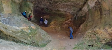
The Sand Cave was our second destination in the NE corner of Cumberland Gap National Historic Park. It is made of such a soft variety of sandstone as to be easily eroded. As is common shallow-soiled sandstone caps, waterfalls are event oriented, a mere drip or a roaring cataract.
Notice in several of the following pictures how walkers are leaning forward. Other than that, the pictures do not easily give away how steep the sand dune floor of the cave is.
The cave is perhaps 250' long along the cliff and up to 100' deep with several alcoves as you see here.
The snow rendered further contrast to the cave.
The roof of the overhang slants downward toward the entrance at about an equal slope the floor, but I assure you that it is steep coming up to the back.
This little overhang within the overhang is the furthest point into the cave. I must admit that I have a bit of a difficulty calling it a cave, though technically it is. To my mind a cave closes in and is totally dark inside. The mouth here is smaller than the room though.
My hiking partner gave evidence all day that the temperature was below freezing. The rhododendron leaves agreed, being hung down and curled.
The day begun with a group Bible Study, continued with an 5 1/2 hour, eight mile hike with 3 hours roundtrip driving, and ended with a Navy Band concert for my wife and me. It was a full and memorable day for which I am thankful to my Creator and Lord and from which I took a nap today. The crowd was near capacity when they began.


