Harper Creep Falls

Harper Creep Falls
Harper Creek Falls

Sunday, July 30, 2023

Ridgewalk

While waiting for my hiking partner, I noticed the most uncommon, common Queen Anne's Lace at road's margin. That such a common weed can be so beautiful reminds me of what Jesus said: "And why are you worried about clothing? Observe how the lilies of the field grow; they do not toil nor do they spin, yet I say to you that not even Solomon in all his glory clothed himself like one of these. But if God so clothes the grass of the field, which is alive today and tomorrow is thrown into the furnace, will He not much more clothe you? You of little faith!" (Matthew 6:28-30)


The Appalachian Trail crosses the road through Low Gap above Shady Valley. I told my hiking partner that the common name, Low Gap, meant that we had a climb up to the ridge. It was a much milder climb than I anticipated.


I had expected some kind of view, hopefully of the lake below the ridge. The only one that we got was from a small field part way up the ridge. The mountains are on the east side of Shady Valley, TN. Someone keeps this totally isolated field cleared. Is it private property with an AT crossing agreement?


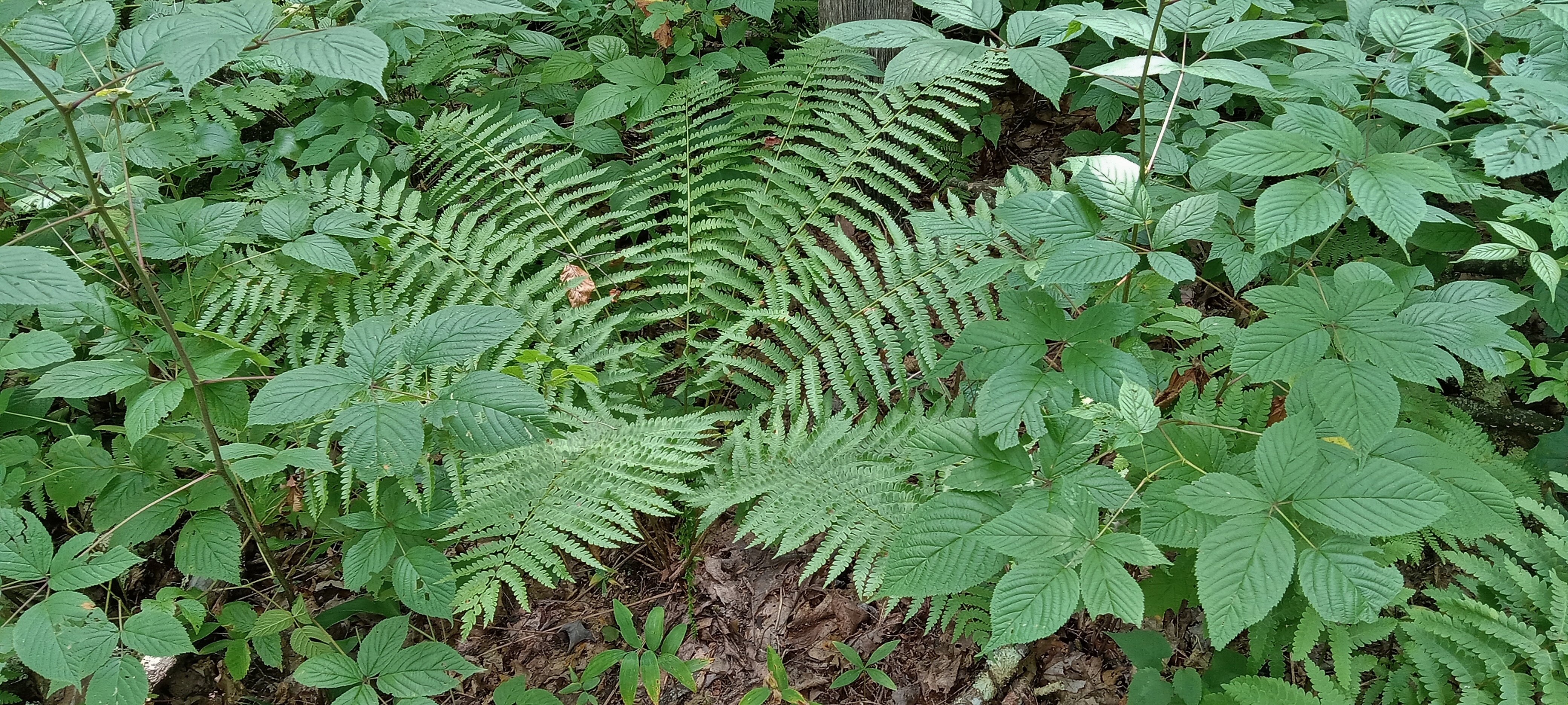
It has been neither exceptionally wet nor overly dry, but the ferns and other herbaceous plants appeared well watered. Perhaps the combination of shade and groundwater flow sustains them in the summer heat.


White Bee Balm is not as common in the woods. It is also curious to me that the blooms do not cover the crest of the bloom pod. Is that because they have already bloomed and fell off, or is it just a how they bloom?


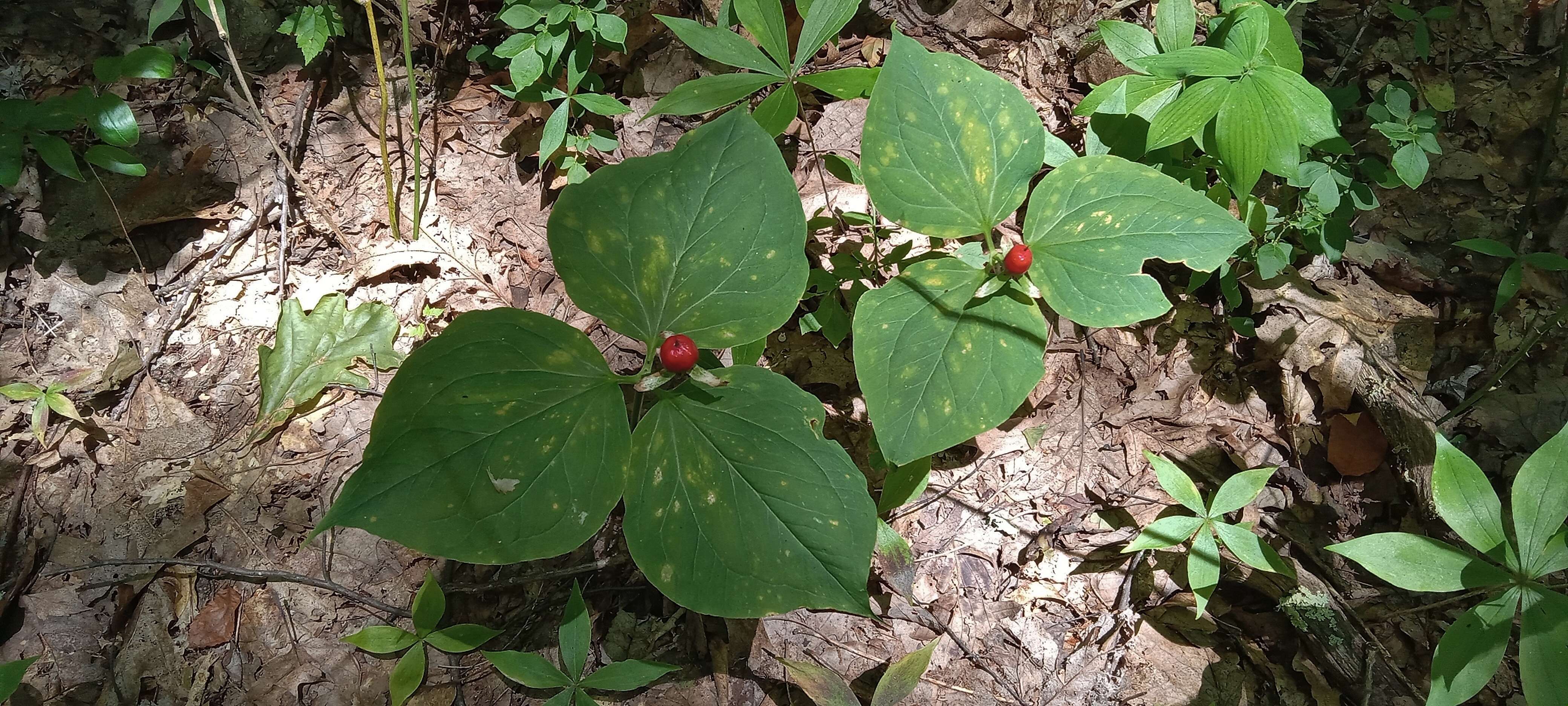
Trillium gone to seed appeared all around. Though a ridgetop, the soil seemed fertile and moist. The lighting in the picture with filtered sunlight looks almost artificial.


This section of trail is actually not as open as the majority of the trail. You can see the smooth, gentle slope though.


Tiger Lily punctuated the green ubiquity.


Am I biased concerning what represents open woods by having been in so much dense underbrush? It did seem like no deer could easily hide in this woods.


I wonder how well this stile would be for any livestock that really wanted to get into the woods. I guess there isn't much drawing them there with shade along the fields' margins.


It didn't slow us down.


The woods here look more like what I remember the majority of it looking like, open with medium-sized trees.


The field must have been 1/4 mile long.


We are told that the weeks long poor visibility may be blamed on forest fires in Canada. So much for reducing carbon footprint.


We had a good 6 1/2 miles, mostly shaded in the woods. The sun was quite intense in the field, but the breeze prevented a miserable traverse. The open field and distant mountains looked so expansive.


We had only seen one hiker up to this point. Another one appeared on the horizon, looking like a through hiker* with the seemingly large pack. When we got close, the hiker says, "Hello stranger." They were my son and granddaughter. her shade canopy was what looked like a large pack far off. My son said that he was trying to call me but was seeking cell phone reception. Face-to-face is better anyway. What a pleasant surprise.


At trail's end he ferried me back to my car and we went to my house where we talked and Mamaw held her granddaughter.


I told my son that I couldn't see his face because of his cap bill. He replied that it was OK since he was an extra. I will assure you that daddies and sons are not extras, despite what some parts of society want you to believe. Sons and daughters need their daddies always and desperately in these crazy circumstances.


*Through Hiker- someone going a significant distance, usually referring to someone hiking the whole of the Appalachian Trail (The third "a" is not long.)


Sunday, July 23, 2023

South Holston Works

South Holston Dam is an earthen dam in such sharp contrast to the green valleys and hills approaching it. That doesn't mean that I am against such structures or their use. Still, it does speak strongly of human ingenuity, engineering, and dominion over nature. The straight lines of the naked, gray limestone boulder terraces used to maintain the dam are not pretty, but they are functional.


Looking beyond that stark functionality, you see a beautiful lake and surrounding mountains. Given its depth and source water, I assume it is probably one of the coolest TVA lakes in the system. (1)


I well imagine that you could not drive across this dam after 911 as you can now. If you look closely, you will see a vehicle parked on the dam while someone got out to take pictures.


These dams are similarly sloped on the lake side under water in order to hold back the multiple tons of pressure per square foot on the bottom of the dam. (2)


Picnic Area


Iron Mountain commands the far side of the lake. There must be a good view on the Appalachian Trail up there. I guess I will just have to go find it.


The structure at left is a standpipe for the generators. The dam was constructed in just over 4 years during a 9-year period, having been delayed by WWII.


There are a half dozen types of turbine blades for hydroelectric dams. (3) The two most common ones for large installations are the Kaplan, which resembles the propeller on a ship, and the Francis, also called a squirrel cage, which resembles the enclosed fans by the same name. I could not imagine why one would wear out and be displayed as we see here. But in my first year of teaching, I secured a tour for my students a tour of the powerhouse and control room of a nearby dam. Quizzing the controller about what he did, I was informed that it took quite a bit of skill to bring a generator online. Before electronics and still on many dams where electronics have not been retrofitted, the operator must manually synchronize the generator with the electrical grid. There is a powerful electrical counterforce to the momentum of the rotating generator called counter electromotive force or counter emf. If not synched correctly, the counter emf can produce such a jerk on the turbine as to detune it. I should have pursued exactly what that means, but I think that it means either that the turbine is warped or the bearings compressed so that the turbine then wabbles like an unbalanced tire eventually destroying itself and surroundings. Sorry about that. I went all science geek nerdy there for a minute.


Another byproduct of electrical generation is very cold, oxygen low discharge water. That makes for a sterile river many miles downstream. TVA came up with an ingenious solution that was implemented below this dam. At two points on the river on either side of an island, they built these grid waterfalls. Their shape greatly increases the surface area of the falling water which oxygenates the water.


Talking to one of the fishermen below this structure, he told me that 14 miles of this section of the South Holston River is considered to be one of the best fly-fishing rivers in the country.


Pedestrian bridge across to the island and walking trails


Technology and man's needs along with nature can co-exist. It is a matter of proper stewardship. I believe that this is what God intended in Genesis 1:26-30 and 2:15, not restricting all of creation to preserves nor trashing it for mere functionality or money. So much of life is a balancing act. I could go all pedantic on this score as well, but I will spare you.


It is a peaceful, cool, and inviting scene. Only God could make it; we must utilize it with care.


1. Exclude Wilbur Lake below Watauga Lake which is a constant 42 degrees all year round because its waters flow off of the bottom of Watauga Lake.
3. Types of Hydropower Turbines | Department of Energy

Saturday, July 22, 2023

Stop and Go

 I was in need of urgent care, so I pulled in "dead stick" as the pilots say.


While I was waiting for my wife to come fetch me, I stood next to the highway where she could see me. The margins had wildflowers like thistle


... and vetch


... and Bachelor's Button.


Work is quick and easy with the right tools. He had the right sequence for efficiency down to a science.


The new car is a similar KIA with more bells and whistles, and certainly less mileage. 


I hope that it will serve as well as the 2007 Elantra that we had from 9000-277,000 miles. We didn't have more than what I would call expected maintenance on it in 15 years of owning it. I took this picture several days ago while thinking about how thankful I am God provided us with such a serviceable and enjoyable car. We have had a few troublesome ones in years past.


Wednesday, July 19, 2023

Linville Falls and Gorge

I think that many people that go to Linville Falls are unaware of Dugger Falls. It is probably no more than 100 yards from the parking lot up a tributary of the Linville River. The falls is only about 15 feet high for both parts. The uniqueness of the scene is the small notch into which it drops.


Here are three out of the four of us standing in the creek.


It is possible to walk with dry feet up to the base and the top of the falls with a little rock scrambling ability. We had too many things of the docket this day for such an attempt.


Instead, we went to the near overlook of Linville Falls, which is more than 150 feet above the river. the overlook is on the knife edge of a fin that extends out from the main cliff. A later picture shows just how tall this fin is.


Next we hiked to the bottom of the falls. It is not a long trail, but it is steep and very rocky. The cliff beside the falls has numerous birds' nests from which adults come and go. The falls actually goes around a large boulder to reunite for the falls you see here.


Downstream the gorge winds in tight S-curves lined by high, jagged cliffs. The shape just above center in this picture is a rock tower.


After several tries, I was able to aim the camera right for the gang sitting in front of the falls. I was observing to the guys how peaceful the loud white noise of the falls is. It feels like a quiet because it blocks all else out, but of course, it is actually loud enough to require almost shouting to communicate.


Notice the light at the top of this next picture. This is not intended to be a picture of me but rather a picture of how small I am compared to the height of the cliff. The fin upon which sits the overlook is on the right.


I have been to this falls many times over the years. I was pleasantly surprised at how long these guys just sat and looked around. The get it. God's Creation is so intriguing and instructive if you will just observe in silence. It is the general book of revelation about God's character, albeit it cannot bring someone to salvation. It does point unmistakably to the Creator.


One of my friends, a fly fisherman, saw a ripple just out from the base of the far cliff and declared a fish had surfaced for an insect. Truly that is evidence for search image.*


One final parting shot


We next traveled around the upstream side of the gorge along Hwy 183 to Old Hwy 105. The trail we sought is clearly picture here.


About a quarter mile in is a small overlook. If you look slightly down and left of center you can pick out the "mound" in the bottom of the gorge, our intermediate destination, Babel Tower.


This is the upstream slope of Babel Tower on the right.


At the "entrance" to the tower are two curious overhanging rocks. You go around or take the quick way down as I did.


You would need a fisheye lens to get the unique view that I am about to describe. The river flows in a tight S-turn around 3 sides of the tower, which has perhaps 200' cliffs on one side. Standing at just the right place, you can turn your head maybe 30 degrees to see both the upstream approach and the downstream receding flow. Following is the downstream with Table Rock in the background.


An upstream stretch obscured by a bonsai shaped Table Mountain Pine.


The color and sheen of this shelf fungus suggested "up to no good" to me. It certainly is a rich color.


Two of us proceeded down the steeper, rockier part of the trail to the river below. This section has a constrained little cascade.


The bottom of the gorge is narrow here with cliffs rising right out of the water. The rock bare up 15 feet reveals how deep the water is sometimes during high flow. This is a very nice swimming hole, deep, with several levels of jump off, sunning rocks and shallow, gentle rapids just downstream on slick rocks for sliding.


I observed to my companion what memories this spot brought out. In former days I had brought my children here numerous times on hot summer days. It is about a 1 1/2 mile hike down, meaning that the cooling you received in the river was soon removed by the hike up out of the gorge. The memory sticks.


Here pictured is one of the easier parts of the trail. My friends assured me that I need to modify my description of trail difficulty. It seems a matter of perspective from experience and hiking practice.


I think this may be Whorled Loosestrife in seed. I have seen it before, but this was the best specimen I have seen.


I think my compatriots were genuinely impressed and challenged by the hikes we took.


I talked of water and cliffs and geology and flora and theology, but they were memories and a feeling of this being home that surged in my heart. I spent nearly 1/2 of my life in these woods. I am thankful for new trails and destinations to explore now, but I cherish the places I have been along with the sense of well-being that time in the woods alone or with others, but always with God's presence, has brought to me.

*"It [search image] is typically used in the context of a predator deploying selective attention for finding cryptic prey." Search Image | SpringerLink Practice enables one to see what others cannot.