Vermont is ranked 49th in population among states. And yet, the capital building has a gold dome. It is not a large building, neither does it sit on a stately plot, being backed by a wooded hillside. Nor is it in a prestigious city, Montpelier being of a population less than 8000. With all of this, a small curiosity from many years past was satisfied, seeing the golden dome.
The main street does undeniably have some beautiful buildings.
I could stand in the middle of the street to take a picture.
From there I headed east along country highways, approaching Mt. Washington from the west with excellent views. I knew that I would have to cross the ridge to get to my destination. I was pleasantly surprised upon entering Crawford Notch from the top. The glacial lakes near the tops of ridges are somewhat common in these parts. Though probably a regional term, notches seem to differ from draws in my part of the country by being very steep-sided with cliffs on either side. They approach a gap at the top, while a draw may approach a gap or peak. Gorges run through the mountains, while notches and draws run up into the mountains.
Always the grandeur of the massive and the beauty of the diminutive. Oh, how His Creation draws us to His person and works.
...and so the cliffs.
Upon arriving at the airbnb where my daughter and family were staying, she was fixing a large meal. We enjoyed a meal together and I went for a walk in woods with my two grandchildren. They loved the idea of exploring, and sure enough, we came upon something unexpected, a level berm running through the woods. I thought at first that it was the dam of some long since drained pond until we came upon the following sign. Evidently, between interest in history and exercise, the roadbed had been maintained as a nature trail.
Early the next morning, my daughter, my great nephew later in the evening arrived, and I started off for the trailhead in Pinkham Notch. A cap cloud hovering above it, we could see our destination before we began. This was the reason the trip to New England had been planned, bagging the only non-TN-NC sixer in the East.
Tuckerman Ravine is the most popular trail to the summit because it is shortest. My daughter wanted a less traveled path.
You can imagine the rush of water during snow melt many of these ravines would have. My daughter stands on the bridge.
At one mile near where we left Tuckerman Ravine Trail is Crystal Cascade at 141 feet total height.
Boott Spur Trail was the poison we chose.
Somewhat past its peak Lady Slipper
Seriously, the trail is steep. My daughter called knee-high step-ups annoying and hip-high ones unreasonable- sounds about right.
When we gained the ridge and above timberline, the ruggedness of the mountain revealed itself. If not melted in mid-June, are they mini-glaciers? Notice the hikers shelter just below center right.
You can see the shelter at left and Lion's Head above. From the map we had thought that we would cross this ravine to Lion's Head. But the sight of it and realization that the contours were 100' intervals caused us to nix that idea.
Much of the trail is quite bouldery, steep, and strenuous to negotiate.
I truly do not know what this bloomin' plant is, but the leaves and flowers suggest some type of diminutive rhododendron.
Ice is an amazing force, grinding slowly and persistently away at any crack.
In the windswept environs where nothing grows above a foot tall, cairns mark the trail. Later pictures of fog and thoughts of snow will suggest the necessity of these structures that also serve as a deposit when clearing trails.
From the first top out of the ridge to the top of Boott Spur was 900' vertical.
One could swear that these inclusions are charcoal, but they are hard and shiny, probably black biotite.
800' more feet vertical plus the bit back down to add on. The camera perches somewhat cattywampus atop my pack while I ran just in time to pose for the picture.
Perhaps quartzite is an appropriate cap for cairns in low visibility, but I do wonder about its utility during snow cover.
The closer we got to it the bigger the cairn appeared. I believe tha it was over 12' tall.
After all the way we came up, it is surprisingly flat up here.
These black spiders scurried everywhere.
Four ridgelines away makes it appear that we are in much higher mountains than we are.
Balancing degree of clothing is difficult in varying degrees of wind, overcast, steepness, and exertion.
The goal met (actually, halfway since we were going to hike back down).
Mt. Washington Summit, 6288'
The obligatory benchmark picture
The weather observatory
A place indoors to sit and eat out of the wind.
Observation deck on the roof of the train station-restaurant-museum
My daughter's family arrives.
The view was soon afterward obscured, and we had light rain for a short period on the descent.
The grandchildren exploring at the base of the weather observatory
I can only think of one other sixer that has towers and buildings on top, Clingmans Peak near Mt. Mitchell. Clingman's Dome has an observation deck and previously Mt. Mitchell did, too.
The wind is calm at 26 mph with highest gust of the day at 42 mph. It is not the Rockies, Andes, Alps, or Himalayas, but for such a short mountain, it is fierce.
Underneath the cloud cover the ridges shown with sunlight. The weather on top can be wholly different than down below.
Nearing timberline
Cap cloud obscuring the summit
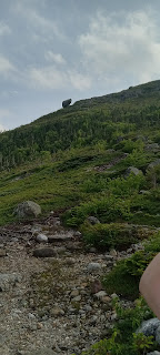
Ok, I have to discuss this boulder. How did it get here? How does it stay? It doesn't seem possible that it rolled to this point and then stopped (see next picture). So, did the surrounding rock and soil and rock erode away. That seems unlikely also since it would have been dislodged, too.
And what keeps it there? Does it have some unseen keel dug deep into the boulders to hold its position?
The total hike was about eleven miles, 4.8 up and 5.2 down. The big step-downs and rock scrambling were at times intense. But for all of that we had done it. Including 1.5 hours on top, we were on the trail for 12 hours. A comfortable airbnb, shower, and abundant supper were most welcome.
We made a lasting memory and have so much to be thankful to God for.


