Harper Creep Falls

Harper Creep Falls
Harper Creek Falls

Sunday, March 17, 2024

Virginia's Highest

Straight off of Hwy VA 603 the trail is boardwalk for 1/8 mile. I guess it had been very muddy. We started out at 7:45 AM after a one-hour drive from my house.


The sign reveals a number of details of our hike: the distance to the summit, the distance to the AT, and how far up we intercepted this trail on the way back (Lewis Fork Trail).


 Herbaceous and evergreen


The fog was thicker when we started but the brightening looked better.


American Beech don't lose all of their leaves until the new leaves emerge in the Spring.


Algae laden shelf fungus says continuous moisture,


...as does moss.


Fog lifted, edge of an old field, glimpses of nearby ridges


Can you figure out how far we have come?


It is so hard to catch what the eye sees, what the mind considers, and what the heart feels in the quiet of the forest. It is melancholy and glorious, intense and subtle, beautiful and daunting, complex and simple all at the same time.


Double trail blazes mean a change in the trail, whether just a sharp turn not to be missed, a trail intersection, or road to be crossed.


Appalachian Highlands are so beautiful and productive and intense. They draw me back again and again.


Within a half-of-a-mile of the summit


Ah, we found it. She is trying to read the peak name.


So, was it set in 1930 and surveyed in 1933?


We puzzled over it for a few minutes when I concluded that it must mean USGS. After seeing the picture at home, I could not pretend that it is a bad G, but a good C tipped slightly. What does it mean? Does it mean USCS- U.S. Coastal Survey since the markers do say "U.S. Coastal & Geodetic Survey"?


When you are focusing on taking the picture rather than being in it!


I came across this second marker on a rock nearby that was a few feet higher. I wondered silently if there should not be two more, like when survey trees are painted on the side facing a corner marker, all with arrow facing the central one with the triangle. My daughter wondered about others aloud since this one says "NO.1", and we began to search. We found no others, but Wikipedia assures me that there are four total.


The summit is forested with no views and therefore a destination for purely destination sake. No, they are not ghosts. There are two clouds forming where sunlight is evaporating moisture in the moss-laden trunks and rocks.


Just down from the peak is small clearing with grass now dried by the pleasantly warm sun. I declared that it was time for lunch.


The approach had been forested with an easy grade, pleasant enough but with no big rewards. So, we decided to return by another set of paths. Soon we were out upon a sunny field with far flung views.


We stopped for yet another view when I glanced a movement in the brush by my peripheral vision. I thought it to be a deer but then looked to see otherwise.


These wild ponies are used to people but keep a distance of 10 or more feet. They graze all year round. In fact, I had once seen them many years ago scratching through deep snow in whiteout conditions for a little grass. Evidently there is a life to be had here since there is a sustainable herd of just over 100 animals (1). We saw three this day.


Administration of wild lands is cloaked in layered bureaucracy. Mt. Rogers sits in the Lewis Fork Wilderness within the Mount Rogers National Recreation Area that also somehow encompasses the Grayson Highlands State Park all within the Jefferson National Forest.


Fabio, the goldened-hair sire of many of the herd, put out to pasture. (1)


I didn't get a good picture, but when he decided that I was too close (~25 feet), he walked right by my daughter.


The two reasons Mt. Rogers itself is not overly exciting: 1) Tree toped without views and 2) Very broad gently sloped summit.


A fairly recent AT shelter. I understand that the vanguard of the class of 2024 AT through- hikers is just south of the Smokies Mountains N.P. It won't be even a month before the first waves of the push north come through this section filling the shelter and surrounding firepits.


Why is it open? That is a past and present question. Was it fire, logging, clearing for grazing that originated this condition? I cannot believe we are seeing natural draft bald conditions since surrounding environs above, below, and beside this are fully forested. And what keeps it so? 100 ponies could not pull this off though they assist. Is it mowed now and then to keep it in its historical and tourist-drawing condition? That seems a little questionable with the present funding and paradigm of the resource managers. What then? Well, it is beautiful.


We climbed atop one crag for the best view. We believe that we were seeing as far as ski slopes in North Carolina. The back side was easy to scramble up but the vertical face in front of my daughter is perhaps 80'.


The lichen was even more fluorescent greenish-yellow than the picture reveals.


You get into a get-there mentality at a certain point, so my last picture is at the end of the trail and the end of my tale. Through fog and sunshine, substantial conversation and silence, forest and glade, easy stroll and wet or rough, it was a good and memorable day. Life is good on the pleasant days and the challenging ones because God is good. I am thankful for this pleasant one.


Saturday, March 9, 2024

88

There is the birthday girl, temporarily tolerating the tiara and veil placed upon her. She is sitting in her favorite place, her sunny back porch, reading thoughtfully through each card and making comments as she goes. Old memories come better to an 88-year old than recent ones. 

There are no young siblings but here stands a younger sister overlooking the card reading.


Second sister and husband and youngest sister


Oldest brother and wife and my wife who is the fourth sister


Lots of stories


...and more stories


A sister-in-law


Big brother stills has a little tomfoolery about him and assisted by his wife, no less.


Because the siblings age range over 24 years, some of the nieces and nephews are barely younger than aunts and uncles. In fact, one niece was older than two aunts. Another sister-in-law sits at right.


Five sisters and a sister-in-law


My wife grew up spending a large amount of time at two older sisters' houses. This brother-in-law has been more like uncle over the years.


I feel as though I could tell you what is being said and some of the responses in thought based on the expressions.


It is good to have family who can be amiable toward one another and want to get together to remember what we share. With the fragility of the family structure, will the next generation get together regularly? This generation is passing soon. Lord, please raise up a godly, kind, family-oriented posterity to replace us. 

Sunday, February 18, 2024

Cliffs and Caves

The Ewing Trail begins at Thomas Walker Civic Park. You can discern from the bundling, that the day was quite chilly.


Given the large cliffs above, it is actually quite surprising that there are not more boulders downslope. However, the one large one had a very curious pattern and color on one flank. It has a significant iron deposit.


We ran into a snowline from the night before. Evidence in the valley suggested that it had rained most of the night and only early had it snow a bit. Here, though light, it seems to have been all snow.


Walking up the mountain caused very little trouble staying warm, but on the ridgeline, evidenced by snow stuck to the NW side of branches, the wind along with the lack of slope to walk made for difficulty staying warm.


White Rocks shone in the sun for just moments, and I caught the tail end of the shine.


The trail switch backed up the ridge for reasons of erosion but also in order to snake between the cliffs.


Bro and Sis stand in the breach for a picture, too.


Not being one to be left out, so did I.


The pitting in the rock, algae and moss, and ice cycles produced an eerie face.


I would guess that the cliffs are 150' tall at this point. Later, on the drive home, I noticed that the cliff runs unbroken for at least two miles to the NE. The ridge and valley system of SW Virginia and E Tennessee lay before us. The breeze abated and the sun peeked out of the broken overcast intermittently to allow a respite, contemplative views, and needed snack.


The next four photos are my "panoramic view" from NE around to the E to the SW. The sandstone caprock was curiously pitted and gapped by more erosion ready rock. Where is the talus and boulder field. Was it predominantly limestone that dissolved?


I think that the hint of virga under the clouds is snow, showers of which we experienced intermittently throughout the hike.


There was no doubt about which way the snow came from.


Later in the trip the brother/sister combo bushwhacked a short distance off trail to the top of yon knob to make contact with seven radio operators, establishing a "Peak in the Air", as the radio hobbyist call them.


A friendly hiker exchanged photography favors with us. We almost stayed to long, since the breeze kicked back up and we struggled to rewarm ourselves. I got in a good conversation with one of the hikers about tree conservation and creation.


I do like hiking and showing friends new places.


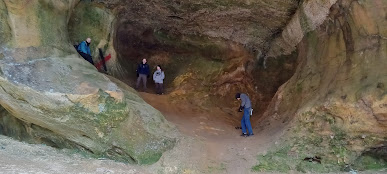
The Sand Cave was our second destination in the NE corner of Cumberland Gap National Historic Park. It is made of such a soft variety of sandstone as to be easily eroded. As is common shallow-soiled sandstone caps, waterfalls are event oriented, a mere drip or a roaring cataract.


Notice in several of the following pictures how walkers are leaning forward. Other than that, the pictures do not easily give away how steep the sand dune floor of the cave is.


The cave is perhaps 250' long along the cliff and up to 100' deep with several alcoves as you see here.


The snow rendered further contrast to the cave.


The roof of the overhang slants downward toward the entrance at about an equal slope the floor, but I assure you that it is steep coming up to the back.


This little overhang within the overhang is the furthest point into the cave. I must admit that I have a bit of a difficulty calling it a cave, though technically it is. To my mind a cave closes in and is totally dark inside. The mouth here is smaller than the room though.


My hiking partner gave evidence all day that the temperature was below freezing. The rhododendron leaves agreed, being hung down and curled.


The day begun with a group Bible Study, continued with an 5 1/2 hour, eight mile hike with 3 hours roundtrip driving, and ended with a Navy Band concert for my wife and me. It was a full and memorable day for which I am thankful to my Creator and Lord and from which I took a nap today. The crowd was near capacity when they began.


Friday, January 19, 2024

Old Backpacking Memories

 Everything about the scene brings back multiple memories. The young men on either side of me are 4 or 5 years older than me, more experienced at backpacking and most everything else, too. The location is Carver's Gap, just below Roan Mountain on the Appalachian Trail, my most frequented section of trail overall. Yeah, I lost count somewhere above 25 times I had been on part or all of this 13.5-mile section that includes the Yellow Mtn Gap of Overmountain Men Revolutionary War fame, Grassy and Jane Balds, Hump Mtn (5587' with 360-degree unobstructed views), Bradley Gap and spring for excellent tent camping, and Yellow Mtn Gap Shelter (i.e. barn). The gap now has a wooden split rail fence, paved parking lot across the road that is crowded on weekends, and a graveled and graded switched back trail up through the woods to the top of Grassy Bald unlike the straight up eroded one you see here. And look at that sign. They don't make them of that quality now. This was nearly the beginning of my association with my backpacking partner on the right of the picture. Looking hardly old enough to be more than halfway through high school, I am excited and full of vigor and green as all get out. I have the same pack as my partner. I sport my new Bass double insulated hiking boots all shiny with Snow Seal wax. I wear my Fostline gaiters for mud that I sewed myself on my mother's machine. We all make the mistake of wearing cotton pants, their jeans and my gray corduroys folding awkwardly on my bowed legs, that block no wind and retain all moisture. I have my recently purchased, used purple plaid, heavy wool shirt that I still have to this day. Growing up in Knoxville, I have a Volunteer Orange and White cap that probably poorly kept my head warm. The leather gloves would have been worse for a soul whose hands just don't circulate blood well. I remedied that soon with wool liners and cotton lined, leather mitts. The picture doesn't well reveal it, but I have a beard of sorts, really a goatee and thin mustache because I could grow no more. My classmates in high school thought of me as confident but I well hid my deep feelings of inadequacy and bouts with depression. I loved everything outdoors and challenging to the body. My wife who was about 6 years future of this picture once said that God made me poor to keep me out of trouble. I probably would have gotten involved in some pretty wild outdoor pursuits given the money. I settled for a pack, a steep grade, hill and draw, woods and fields, trees and flowers, creeks and peaks, cold and heat, sun and rain and snow, minimal food and hard sleeping, quiet company or walking alone, and I called it fun and a hobby. The scene is probably late winter with patches of snow and dead grass tops. Wind sculpted Red Spruce and Balsam Fir outline the ridge with naked deciduous brush all down the flanks. The wilderness in general has a melancholy feel, all the more in the winter. The temperature and wind chill are only ameliorated by the bright sunshine. It feels like a good day for a hike!


God has been good to me to allow me to start early and continue hiking these nearly 50 years. I still go at it hard and may get to go overnight again one day soon.